Day 151 – Tywyn to Llanaber 17.5 miles 1978’ ascent

Sunday 14th November 2021

Today was the first day for months that we have had a cooked breakfast at a B&B before walking. Our host is very happy to provide a 7am breakfast even on a Sunday. He said that, because the trains weren’t running, he had been getting up to provide one guest with a 5.15am breakfast during the previous week – so getting ours for 7am almost felt like a lie-in.

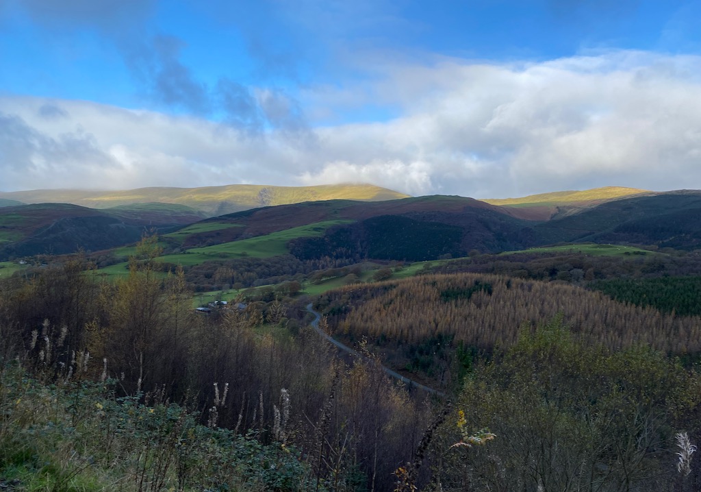
We drove to Tywyn and parked on the promenade which was free at this time of year. We set off along the promenade and then along the road to where there is a modern bridge for pedestrians cyclists and horses over the Afon Dysynni. Previously the coast path made a considerable diversion inland. There was a strange mix of memorial plaques on the bridge including one to a soldier and young child. Over Broad Water we came to Tonfanau after which the path turns inland a little and uphill and for the next three miles or so we were walking parallel with the coast but 200 or 300 feet up. The coast road is not one for walking along. It is cut into the side of the hills with rock on one side and a stone wall the other and no pavement or refuge from passing cars.

The rusty rails of unused track at Tonfanau
The estuary of Afon Mawddach and Barmouth beach

We dropped to almost sea level at Llwyngwril and crossed the river Gwril before climbing back up to the hills again.

A telephoto shot of work on the Barmouth Bridge viaduct.

We realised that we were going to reach Morfa Mordach, the station on the south side of the R. Mordach and the Barmouth Bridge, soon after 2pm and, though it was still several miles away, it would make it a very early stop for the day.

At this point I should explain that Barmouth Bridge, the viaduct across the estuary, is a Grade 2 listed building, being the oldest wooden viaduct still in use in Wales and possibly the UK. It was completed in 1867 and carries a single track railway and a footpath (part of the Wales Coast Path). Unfortunately extensive restoration is now required and so the bridge is closed intermittently to enable work to proceed. Network Rail, the owners of the viaduct, have closed the footpath.

In the summer there is a ferry that plies across the estuary and, looking on their Facebook page, it said that the service was continuing during the bridge closure but they did not say how long beyond the summer season they would continue. I had rung the ferry boatman yesterday and he confirmed that the ferry service had been closed and he could not do a “special” because the boats were out of the water. I checked the Network Rail site which confirmed that the footpath alongside the railway was very definitely closed for safety reasons. We had considered ending today’s walk on the south side and continuing tomorrow from the north but now, being ahead of schedule, we decided to do a “virtual crossing”. We would walk to Morfa Mordach station and get the train replacement bus to Barmouth and resume walking on the other side of the estuary. The road the bus takes is totally unsafe for walkers.

Passing Pen y Garn

The coast path follows an elevated route around the side of Pen y Garn before dropping down through forestry land to Fairbourne.

The bus was due at 14.11 and as we came into Fairbourne at about 13.30, we had just over two miles to go. So we just pressed on as hard as we could. I went ahead so I could sweet-talk the driver and give Jill a few minutes in which to catch up. I arrived at the station with four minutes to spare and rushed around trying to find confirmation of where the bus would actually stop (after last night’s cock ups). In the meantime Jill texted to say she had lost me (she had followed the path further on across the railway line rather than turning on to the station platform) so I rang her to give her directions just as the bus arrived. As I was talking to the driver, Jill arrived at the end of the platform having had to run a few hundred yards along the way and we both tumbled into the empty bus. I asked for two singles to Barmouth to which the driver said he didn’t take money so we had a free ride to Barmouth.

Walking (fast) along the sea wall to Morfa Mawddach station

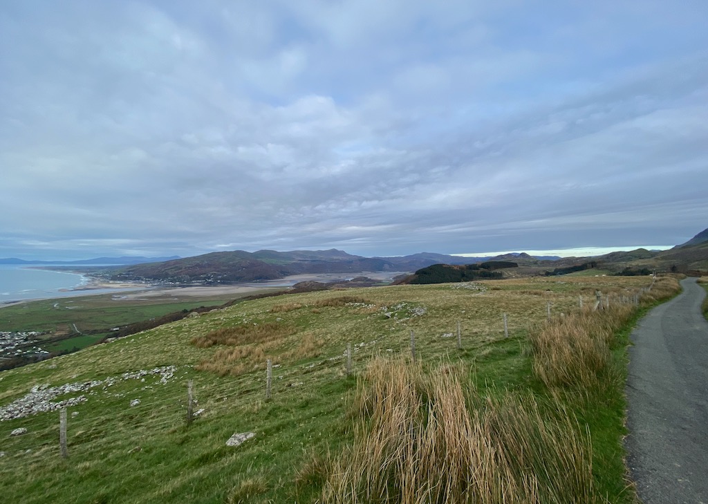
At Barmouth we walked back down to the end of the estuary where the bridge comes across. We were reassured to see several groups of men hard at work. It would have been galling had the bridge been quiet and we had still been forbidden to cross it.

The Mawddach viaduct and bridge

We took our photos then turned around again to walk up the coast as far as Llanaber where there is a station where we could pick up a rail replacement bus back to Tywyn. 

Cardigan Bay Dolphins sculpture – Barmouth
The end of Barmouth Beach

To our relief the bus arrived on time where we expected it to. There was one other passenger. We climbed aboard and once again no fare was required and so we rode free for over an hour back to Tywyn. We can certainly see the benefit of the rail replacement service; there are no ticket machines on the stations so usually tickets are bought on board the train – but replacement buses don’t have the technology for tickets.

Day 150 – Machynlleth to Tywyn 17.2 miles 2580’ascent

Saturday 13th November 2021

We checked out of the Premier Inn at Aberystwyth (Premier Inns have previously served us well but since they stopped servicing the rooms at all because of Covid but still charge rates as if they were, Jill in particular has looked forward to checking out much more than checking in) and drove to Machynlleth to resume the walk.  Leaving the town through the roadworks, we then came to a sign welcoming us (and everyone else) to Snowdonia.

As we crossed the old bridge, we wondered if they might now have extended the cycle path we had used yesterday, as far as Pennal and save the long climb up through the hills to avoid the hazardous road. Sadly, no such luck and after a short distance dicing with death on the main road, we turned on to a very steep minor road which soon became a track as it climbed into the hills above Machynlleth. When the track ended we climbed further through fields and into forestry land. It felt like a very long climb simply to avoid the perils of walking along the road.

Getting into the hills

It was a warm day for mid-November and we were both walking in just our shirts (well we had trousers and shoes on as well). The path descended to join a forestry track which took us down to Pennal where we will be staying for the next two nights. 

We crossed the road and walked through the McDonald Resort and we were both glad we had not booked a room there. We did make use of one of their picnic tables in their nature walk area for our coffee stop. More of that later.

From near our coffee stop we could see across to the rail bridge over the Afon Dyfi. It was this bridge that yesterday we had decided against trying to cross and had made use of the cycle path instead which had at least saved us a couple of miles.

The rail bridge across the Afon Dyfi

Shortly after leaving the MacDonald Resort estate we passed through another premises which had this amusing notice.

It reminded us of a walk about forty years ago when a rather tubby beagle, named Merlin, rushed out of a farm in Longsleddale, ignored his owner calling him back and determinedly walked with us all day (apart from when he needed to be carried over the stiles) and then trotted back into the farm when we passed it again six hours later. We later learned he made a habit of going off with strangers.

Soon after this, the coast path returned to cross the main road to follow up a minor road which became a track and rose slowly but surely to become the “Panorama Walk”.  A couple of female runners went past us and they had bib numbers so we guessed there was some running event going on  though we thought it odd we had not seen any other runners.  Further on there was an arrow marker sign which confirmed our assumption of an event. The cloud was low and we were chilling off in spite of walking uphill at a reasonable pace.

Later we came to a feeding station and we stopped to chat to the marshal who insisted we should sample the Bara Brith and cheese provided for the runners. It was a small event with just 45 starters, some running a half marathon and others doing a second lap for a full marathon.  Later a lone female passed us and we wished her well; she explained she had missed a route marker and had done an extra five miles so knew she would be last to finish. 

The Panorama walk was a little lost on us because the cloud descended and we just had a 360 degrees of cloud. 

The Panorama was largely shrouded in cloud
The Dyfi estuary – crossing it had involved over 25 miles of inland detour.

We carried on and descended to the road at Aberdovey; the village is quite pretty. We found a sheltered bench on the quayside and ate our sandwiches. 

The remainder of our walk to Tywyn was a doddle. It was four miles of damp sand. 

Afternoon light on the way to Tywyn

We came to Tywyn as the sun dipped between the cloud and the horizon and sent a dazzling yellow light across the sea. 

The beach at Tywyn

Then things started to wrong. We walked to the station to wait for the rail replacement bus. There is a wide road with free parking sweeping up to the platform. I checked the timetable which confirmed the replacement bus times. There were, in theory, two buses we could get because there used to be two trains, one that stopped at all stations and another faster train which would arrive later and have fewer stops but arrive at Machynlleth at the same time as the earlier bus. So we had nearly an hour to wait. Jill suggested we try a taxi instead but the local firm she tried were not answering the phone and to wait for a taxi from further afield was probably not going to be much quicker than waiting for the bus – so we waited.

We sat in the shelter on the platform until the first bus was due but nothing materialised and so we waited the few minutes for the later bus, but that also failed to appear. I rechecked the timetable and there were definitely buses due on a Saturday. Then, by chance, I glanced at another display board which had posters mainly in Welsh. When I found the English is said that the buses did not stop this side of the railway, nor the other side, but further up the road outside the Co-op. We raced on to the platform, across the rails to the other side and up the road to the Co-op but of course we were too late.

The only thing to do was get a taxi or wait another hour for the next bus. I rang for a taxi – the first firm still had its phones turned off and the next firm had no availability so, cursing our luck, we resigned ourselves to waiting for the bus – this time a normal, service bus. It was getting quite cold. The time for the bus came and went and I gave it a good five minutes before hitting the phone once again to try for a taxi, needless to say there was no joy from the firms I had tried previously but a third more distant firm said they could pick us up in about ten minutes; Jill rued not trying their number soon after we had first arrived. So we settled on that and I hung up. At that very moment the bus rounded the corner; a bird in the hand and all that; we got on the bus and quickly redialled to cancel the taxi.

It was pitch black and the road quite windy. The bus was going like the clappers to try and catch up because the only other passenger had a connection to make at Machynlleth. It transpired that at one point the bus goes up a dead end and has to reverse round to come back to the main road. On that night, cars were parked blocking his normal turning point and he had to do what he described as a “twenty point turn”. He was a cheerful Brummy and asked us where we actually wanted to be and dropped us right outside the car park which saved us a 20 minute walk from the bus station.

As a bit of a post script to the day; as I was drying myself after a shower, I felt something on my wrist. A closer inspection showed that a tick had hitched a lift and imbedded its mouthparts in the soft skin on my wrist. It could not have been there long because it had not swelled up at all. Jill extracted it for me. It left an itchy swelling on my wrist and a week later a little itchy swelling persists. I guess I picked it up when we stopped for coffee at the bench in the MacDonalds Resort nature reserve. It is a salutary reminder to everyone to check themselves after a walk on the wild-side.

Day 149 Aberystwyth to Machynlleth 20.2 miles 2500’ ascent

Friday 12th November 2021

Today turned into something of a surprise. The plan was to walk from the hotel in Aberystwyth to Glandyfi Castle a few miles short of Machynlleth.

We awoke to a windy outlook from our room overlooking the seafront. Every so often a squall of rain lashed the windows of our room and so we set off in full waterproofs and kept them on all day.

From the end of the promenade, the zig-zag path climbed steeply, crossing the cliff railway twice. Once on the cliffs we looked back over a stormy seafront.

Aberystwyth seafront

The next four miles to Borth were very up and down. There were views into small bays and the cliffs were impressive but the drizzle and mist meant the near views were not very photogenic – and we simply couldn’t see the long views at all. At one point a red kite flew close by, almost stationary beside us as it flew against the strong wind but the heavens opened and photography was out of the question.

Coed Llechweddmelyn

As we came to Borth, the final climb was up to the top of a hill with a war memorial.

War memorial at Borth

From there we had a rather misty view of the Dovey River and the marshland around the estuary.

Borth village stretched along the sea front. (From the war memorial)

I had told Jill that Borth was the only place we might find coffee but I was far from certain we would succeed. Jill said she really wanted to find somewhere warm to sit and rest for a few minutes to have a warm drink. We asked a dog walker and she doubted if anywhere would be open. In the local NISA store I bought a paper and was advised that round the back of the Railway Arms we were sure to get a coffee from the pub. Unfortunately we drew a blank there. I spotted a sign to an outdoor seating area and barbecue hut which opened on to the beach at the rear of another pub. There was no cover but we knew we were soon about to turn out of the village on to the marshland so resigned ourselves to perching at one of the tables, huddled against the wooden panelling; it didn’t seem to offer much shelter from the wind which had been gusting at 40mph. So we had a miserable, brief stop then had to move on again before we got too cold. Just a few paces further along the main street, we found the village’s best kept secret – an attractive, open coffee shop. Jill burst into tears but we just kept going; we had had our coffee stop and really couldn’t have another break straight away.

The path across Cars Fochna

We then followed the Wales Coast Path as it turns inland to cross the Cars Fochna, a marshland. It was a dreary walk; it may be a Wales Nature Reserve but with very few birds and a very waterlogged path, it soon became monotonous. The main interest became avoiding the piles of debris that a digger had been dredging from the drainage canal next to the path.

We came to Tre Taliesin and then walked to the neighbouring village of Tre’r-ddol where there is a community shop, café and other facilities. Unfortunately due to staff shortages the café was closed. However they were happy for us to sit at one of the outside tables under cover and reasonably sheltered where we had our sandwiches.

Over lunch we hatched a bit of a plan. Since we had walked quite fast (mostly to keep warm and because there had been nothing worth stopping for) we were likely to reach the end of today’s planned walk at Glandyfi by about 3pm. From there we had a choice of onward route; we had toyed with the idea of following the example set by John Merrill and reducing the length of the inland detour to the road bridge over the R. Dyfi at Machynlleth by walking over the railway bridge – saving us about 8 miles. We eventually decided against it because one walker reported on-line that there was a very pointy fence he had difficulty climbing over, not to mention a £1000 fine for trespass on a railway. Also, I was concerned that the footpath on the other side seemed to cross some very boggy ground and, on aerial photos, I was not certain we could make it dry shod. It really did not feel like something to consider trying now in failing light.

Going on from Glandyfi on the official coast path wasn’t an option now either as it would take us on a long route into the hills and away from any bus stops.

I then realised that the 1:50000 scale map showed a cycle way from Derwenlas to Machynlleth, presumably created since the official Wales Coast Path was routed away from the road through the hills. I checked in the community shop and they confirmed it was usable. So from Glandyfi we could initially walk the main road, making judicious use of the limited verges, and then follow a minor, gated road through to Dewenlas and the cycle path. As Jill pointed out, we had head torches, we would be on the cycle path before darkness fell and the train from Machynlleth was at 18:05. We decided to wait and see what time we got to Glandyfi before finally deciding whether to go on into Machynlleth.

The wooded walk through the hills lifted our spirits.

After lunch we headed along the coast path which was mainly in the hills overlooking the River Dovey. The walk was very pleasant as we shuffled through the autumn leaves which covered the paths.

The rather dismal view across Afon Dyfi
Above Glandyfi

A change in surface and a different outlook helped the miles slip by and having reached Glandyfi by about 15:00, we decided to follow the plan to keep going to Machynlleth. We headed along the main A487 trunk road. Though there was no footpath but we could walk on the narrow verge and, where that disappeared, we walked very carefully along the road, standing in the hedge when cars and lorries came past. It was only for about half a mile but we certainly would not have wished to walk much further along such a difficult trunk road.

At Pont Llyfnant we took the minor gated road which took us to Derwenlas from where the cycle track would take us into Machynlleth. The cycle path was easy walking and though we had to put up with the noise of cars and lorries, it was not unpleasant. We were making good time and Jill pointed out that we could make Machynlleth in time for the 16:50 train. As it turned out we were walking into Machynlleth at about 16:10 and to our surprise there was a T2 bus for Aberystwyth at the bus stop in the main street. We started running and I waved madly to the bus driver who waited for us to get on and we thanked him for doing so. It was a very fortunate set of circumstances; now I just needed to reschedule the rest of the walk!

Day 148 – Aberaeron to Aberystwyth 17.5 miles 1772’ ascent

Thursday 11th November 2021

Today was to be a fairly straight walk up the coast with only one river estuary, requiring a walk inland of about three quarters of a mile.

Leaving Aberaeron, we followed the promenade until it gave way to a pebble bank and then became a grassy path between field margins and the low cliff tops. It passed through the little village of Aberarth before returning to the edge of the cliff.

Llannon (Plas Morfa white building in the centre)

At Llannon the path takes to the pebble beach and one is required to cross a shallow river. The alternative is quite a long inland diversion. There is apparently a third way which we followed. A good vehicular bridge crosses the river into a property called Plas Morfa, which may have been holiday apartments or similar – it appeared to be deserted and rather run down. Although there was a sign directing us to the long inland route, (and a faded handwritten notice about trespassing) in the apparent absence of any residents, we/Jill decided to take the short walk over the bridge and along the grass at the top of the low cliff to the steps we could see leading down to the beach. The flaw in this route, that wasn’t visible until we got there, is that the steps to the beach are the other side of a fence with double stranded barbed wire, effectively ensuring no one takes this shortcut. As we started to retrace our steps, I noticed there were a couple of vehicles parked around the other side of the building and so I hoped we were not about to be challenged by angry owners. Walking back along the cliff top, we realised that just opposite the house, there was an area of cliff collapse which gave us access to the beach. So we quickly made our way down on to the beach and as far as I know any occupants of Plas Morfa were unaware of our intrusion. We passed the steps we had not been able to access and then followed along the pebbles to the steel steps further along which we climbed to return to the grass path.

The collapsed cliff at Plas Morfa and the inaccessible steps to the beach

Subsequent research shows that Plas Mofa was a hotel but the last Tripadvisor review was back in 2019 and all booking sites refer users to contact the hotel directly. There is no website or telephone number so I think we can assume it has died.
We stopped for coffee on one of the benches just by Llansantfraed and then walked through the village past the church.

Llansantffraed village

The church is unusual in that its south wall been clad in slate tiles whilst the north wall and tower are of exposed stone. Presumably it was hoped this would weatherproof the building.

The tile-faced south wall of the church at Llansantffraed

From the village we followed an agricultural track that was very thick with mud. In places it was impossible to avoid the ankle deep mud and this slowed our progress significantly.

The shingle beach approaching Llanrhystud

After a couple more miles we had the day’s major diversion as we had to walk inland to Llanrhystud to cross the river; we made use of the forecourt hose at garage there to lighten our boots by washing off the layer of thick mud.

Thus far we had hardly climbed at all; the path had been remarkably level but once we got back to the coast, that all changed and the second half of the day had plenty of ups and downs. We soon found ourselves at an altitude of 350 feet with good views. The path was quite narrow and the bracken-clad slope dropped away at an angle too steep for stopping any fall. Jill dislikes these sections of the coast path and tends to look carefully at the ground ahead rather than the view.

Onward along the cliff top towards Aberystwyth

About three miles beyond Llanrhystud we came across an an unusual sight. We have helped distressed sheep more than once on our various walks – Jill even lambed a sheep that had got into difficulties when we were walking the Dales Way. On this occasion a young ram had tried to jump a barbed wire fence but had not made it . The poor beast had its front legs on the ground but its hind legs not taking any weight with a strand of barbed wire supporting its hind quarters. We took a hind leg each and the ram gave a good push and it extricated itself from the fence.

Ram rescue

The path stayed true to the cliff edge for several miles but at Morfa Bychan we had to climb inland to avoid yet another caravan park.

It was one of those annoying days when there was no bench to be found anywhere near lunchtime and so we sat each side of an old, redundant stile.

Dusk was creeping across the sky as we came close to Aberystwyth but behind us the sea was dazzlingly bright under a break in the clouds.

Looking back towards Aberaeron

The path continues along a ridge that ends at Allt Wen where there is a very steep drop to the Afon Ystwyth, one of two rivers entering the sea at Aberystwyth, the other being Afon Rheidol.

Allt Wen with Aberystwyth beyond

Just as we were approaching the descent, Jill had a sudden pain in her knee which stopped her in her tracks. She has had intermittent pain ever since her cartilage operation nearly two years ago; she thinks it comes from the supporting ligaments rather than the joint itself. This seemed to be rather more significant than previous pains she had experienced (or maybe she was just close enough that I heard the yelp) and I was very worried about how she would cope with getting down the very steep, muddy ridge path and into Aberystwyth. There wasn’t much option but for her to take it literally one step at a time and with the help of her walking poles and avoiding bending her knee too much, Jill worked her way down to reach the pebble path along the bank of the Afon Ystwyth. Once on the more level terrain she could adjust her stride to avoid it pranging badly again and we walked into Aberystwyth just in time for the 16:10 bus back to Aberaeron.

Aberystwyth Harbour
Light fading across Aberystwyth Harbour

We then drove back to the Premier Inn in Aberystwyth. Remarkably Jill’s knee seemed to settle again and after supper we took a gentle stroll of about a mile round the harbour to knock that off tomorrow’s walk; we would now be able to head north from the Premier Inn without going back into town.

Day 147 – Penbryn to Aberaeron 17.4 miles 3200’ ascent

Wednesday 10th November 2021

We are staying at a super self-catering cabin in Llangoedmor. Our hosts are Katerina and her mountain guide partner, Mark.  It has suited us perfectly. Chatting to Katerina last night about our walk, she said she was really keen to help us on our ”adventure” and very kindly offered to to drive with us to Aberaeron where we could leave our car, then she would drive us back to Penbryn to resume walking. What a fantastic offer! That would mean no chasing to catch a bus and we could avoid the 1.5 mile walk back down from Sarnau to Penbryn.

So, having driven our car to Aberaeron, we were back at Penbryn and started walking at about 9.30. The ground was running wet from the overnight rain but the air was clear and there was thin, high cloud.

Carrag y Nodwydd

The path started with a steep climb and then returned to the cliff edge. The views were wonderful; the sea was completely calm – so much so that we could hear music from the radio on a fishing boat out in the bay. The cliffs were cloaked in browned bracken contrasting the green of the grass; the colours were distinctly more autumnal now than when we finished the previous leg of our walk in October.  

Ynys Lochtyn

The walking was quite hard going. The narrow path climbed up cliffs and down to little bays. We passed Llangrannog where we made use of the loos but decided we did not have time to go in somewhere for coffee. It is named after St Carannog who landed here in the 6th century to begin his ministry to the Welsh

Statue of St Carannog

Continuing on we contoured around Pen y Badell, a prominent conical little hill. The path continued up and down the declivities of the cliffs and so we were not managing to walk very fast.

The beach at Llancrannog
Ponies grazing, Ynys Lochyn
Commemoration stone for the opening of the Ceredigion Coast Path

The day had really warmed up and Jill was complaining of overheating even though she was in shirtsleeves. Having passed over a couple of benches at Pen y Badell, we found none further on so eventually sat on the remains of a stone wall for our coffee and enjoyed some of Katerina’s homemade banana Bara Brith that we had found on the table for us, along with other goodies, at the cabin when we arrived.

Moving off again after perching on the wall for a coffee break.
Csatell Bach

After a couple more ups and downs, we came to Carreg Draenog where there is a very nice shelter or observation room with seating both inside and out. We sat outside and enjoyed our lunch as the sun eventually emerged.

Lunch at the observation shelter, Carreg Draenog

Setting off again, the path disappeared over the cliff edge in an improbable direction. However, there was no doubting it was the correct path because a sign offered an alternative in order to avoid the cliff edge path. We declined the offer and in fact the really narrow bit of path was only a matter of a few yards before it broadened out and rejoined the main path. A couple approaching this section from the opposite direction asked us what it was like and we told them it was very easy though the path was quite narrow. They were not convinced and took the inland route.

Jill saw a chough, with its unmistakable red bill and legs, take off from just beside the path but couldn’t get a photo. We hadn’t expected to see any choughs again after leaving Pembrokeshire which is where a large proportion of the British chough population are found.

Soon after that the path descended into New Quay where I had hoped we would be able to walk the beach. Unfortunately the tide was still too high to get round a rocky outcrop and so we walked along the high tide route through the town along the road until it rejoined the low tide route. 

New Quay

The walking now was much easier without so many ups and downs. I was aware that we were on quite a tight schedule if we were to get to Aberaeron before dark. We still had five miles to go at 15.30 and sunset was at 16.45 and so we were bound to be finishing after the sun had left the sky.

Bridge over Afon Drywi
Afon Drywi Waterfall on to the beach

Where Afon Drywi comes to the edge of the cliff there is a quite impressive, if quite small, waterfall that drops over the cliff and on to the beach below. Jill had spotted this at New Quay and asked if it meant a long inland diversion but I reassured her there was a footbridge which we could now see. We crossed the river and then took a shortcut up the cliff. As we walked the last three miles, we kept watch behind us as the sun dipped below the hills and an orange glow seeped across the sky.

Watching the sunset

As we came into Aberaeron, we walked the shingle bank above the beach to the harbour mouth with good visibility but, within a few minutes and by the time we reached the car, darkness had engulfed the town. We walked past the car to the promenade and watched the dramatic orange light as the last of the suns rays descended behind the hills.

Aberaeron Harbour
Sunset

Day 146 – Cardigan to Sarnau 17.6 miles 2464’ ascent

Tuesday 9th November 2021

Now that the clocks have changed, we need to start our day’s walk early each morning so that we finish before dark. We drove into Cardigan and parked in the Gloster Row car park which was accessed via such really narrow lanes that we thought Mrs Google was leading us astray. The good news was that parking charges in that car park have been suspended for some reason.

The start of the Ceredigion coast path Aberteifi (Cardigan) – where we ate our lunch at the end of our last trip.

We set off and rejoined the coast path at Cardigan bridge at about 8am. The path more or less follows the riverside as far as Gwbert where we were required to dive inland around a hotel and a “Farm Park”  before reaching the coast proper shortly before Pen Tew. This section of path was mainly around field margins and a bit dull. However, once back walking on the cliff tops, it felt much better. The day was quite dull with a light, misty drizzle.

Cardigan Island where we got back to the proper coast.

There was little remarkable to note; at Ty-newydd we found a bench for our coffee stop. Moving on, we passed the Foel-y-Mwnt – a little hill alone on a peninsula with a simple chapel at its base.

Foel-y-Mwnt
The chapel at Foel-y-Mwnt
Haltling Bigni
My heroine

From there we continued the gentle ups and downs of the path and peered into the clefts in the coastline until we came to the the Defence Evaluation and Research Agency site just outside Aberporth. There is the usual array of old and new military buildings and a smattering of rotating radar receivers. Slightly to my surprise, as we passed the gates, an old rusting hull of a large boat of some sort was being brought out of the site on a long low-loader with an escort. It was difficult to imagine what it was doing there and indeed why they were getting rid of it at some considerable expense.

Defence Evaluation and Research Agency Aberporth

We walked on into Aberporth which has two beaches separated by a rocky spur.

Aberporth

We rounded the second beach and settled on a bench for lunch at about 12.30; unusually early for us but we had been walking at 3mph since we set off four and a half hours before and were ready to stop. We were entertained over lunch by a fisherman doing various manoeuvres in the bay before taking his craft on to a waiting trailer to tow it up the beach.

Bringing in his boat

After a morning walking very hard, the bonus was that we had only about five miles to go after lunch, with two and half hours in which to do it and catch the the 15.30 bus.

Penbryn Beach

There were a few steep climbs and sets of steps but we managed to continue a good pace until we came to Penbryn where we left the coast path and turned inland. We walked across a deep valley with a very busy stream and came to the road at the little beach car park. We then had to walk up into the village of Sarnau for the bus. It felt like a very long one and a half miles from Penbryn, not least because it was relentlessly uphill. When we got to the main road we still had a forty minute wait for the bus and Jill having opted for the bus stop with a bar “seat” rather than one further down with nothing to sit on, we didn’t get to see the farm shop hidden round the corner where we might have got a cup of tea and kept a bit warmer.

It was a hard day’s walk but we actually finished much earlier than we usually do. The bus was on time and in half an hour we were back at our comfortable AirBnB in Cardigan.

Day 145 – Ceibwr Bay to Cardigan 8.9 miles 2013’ ascent

Thursday 14th October 2021

Today was just a short day. We have a little over eight miles to walk into Cardigan where we are ending this walking session and then driving straight home. We packed up the car and drove to Ceibwr Bay where there are just a small number of parking spaces.

We crossed the bridge over the stream which runs into Ceibwr Bay by the bridge of very large slabs of stone and climbed the cliff path beyond. It was nothing very severe.  The weather was remarkably warm but the views lacked clarity.

The cliff path undulated gently until Pwllygranant where the path drops but not all the way down to the bay. Then there was a steepish climb with some decent steps to bring us to the cliff top once more.  In a few hundred yards we were at Pen yr Afr, the highest point on the Pembrokeshire Coast Path at 175m (almost 600 ft). For those walking the Pembrokeshire Coast Path in the recommended north to south direction they reach the highest point of their walk after just a couple of hours on their first day; then it is all downhill.

the approach to Cemaes Head

After 3/4 mile we came to Cemaes Head but the views did not even merit a photograph. Then we had a pleasant half mile of cliff walking before we came to the road at Alt y goed and thereafter it was a road walk into Cardigan for the last four miles. The sun came out and it became very warm. At Poppit sands we sat on a bench outside the lifeboat station and enjoyed our coffee in the full sunshine.

I kept an eye open in St Dogmaels for the the marker for the official start to the Pembrokeshire Coast Path but I missed it because I was preoccupied looking at the little jetty right by the coast path marker.  Having now looked on-line, I see the marker for the start of the coast path is a rather insignificant pillar of block stone; rather disappointing.

We came into Cardigan over the old bridge and wanted a quick celebratory lunch. The café attached to the castle seemed ideal. Sadly, after waiting some time to be seated, we seemed to wait even longer to have orders taken – so long in fact that we gave up and left. Not wishing to have a further delay when we had a long drive ahead of us we bought a couple of baguettes from the sandwich shop and sat overlooking the river to eat them whilst I arranged a taxi to get us back to our car at Ceibwr Bay.

Cardigan Castle

Day 144 – Pwllgwaelod to Ceibwr Bay 15.6 miles 3077’ ascent

Wednesday 13th October 2021

We decided to park at Moylgrove (just inland from Ceibwr Bay) near the finish of our walk and get a taxi back to Pwllgwellod.  That meant we didn’t start walking until about 9:40. The day was pretty damp with the cloud sitting close to the cliff tops and a steady heavy drizzle so we had full waterproofs on which was not ideal because it was quite warm.

Dinas Head

We set off climbing up to the cliff path and steadily climbed until we came to Dinas Head. Then we turned hard right and started walking back round the other side of Dinas Island (which is not an island just a peninsula with a narrow neck) to the pretty little village of Cwm yr Eglwys. We stopped here and had coffee and, on the map, I could see that we were barely 500 yards from where we started walking this morning – such is the nature of peninsulas.
The end wall of the church is all that remains of the original which gave the village its name. A huge storm in 1859 washed the rest away. “Visit Pembrokeshire” claims that this storm was responsible for all the pebble banks in Pembrokeshire including at Newgale (and not the change of sea level associated with the last ice age – see entry about Newgale beach).

Remains of the church at Cwm-yr-Eglwys
Penrhyn yr Fforest

From there we walked along the cliffs to Newport, where since the tide was on its way out, we could walk the foreshore path.

Newport tidal path

We stopped for coffee at the pub and coffee shop. It was good to have somewhere inside for coffee and danish pastries. We had a slightly chilly reception, or so it felt, partly because they were still serving everything in paper cups and disposable packaging and they were a bit sniffy about face masks. We took the opportunity to remove our waterproof trousers as the rain had eased and we were getting much too warm.

Newport Sands

Newport is not much of a port and there seemed very little evidence of an “old port” anywhere. We walked up to the road bridge to cross the river estuary and then started up the coast path again; the sky was brightening and the sun peeping through. We were prepared for a tough walk this afternoon but the variety and interest helped make the miles slip away.

Juvenile cormorant at Newport

We started with a steep drop and and equally steep climb at Pen Pystyll. Thereafter for most of the way we were following the undulating cliff top path.

The under-cliff was dense with bracken and brambles which were turning brown.  The cliffs were generally higher than those we have previously been walking around the Pembrokeshire being about 300 feet high.

The cliff line is rugged with very steep cliffs and with deep clefts and jagged rocky outcrops. We had our usual problem of being unable to find a bench to sit on for our lunch. In the end we found a couple of flattish rocks at the end of a wall.

The highlight of this afternoon’s walk came towards the end where the rugged coastline has resulted in natural arches and a spectacular short section of coast. At Pwll yr Wrach there is a natural arch caused by the collapse of a sea cave.

Pwll yr Wrach
Cliff looking at the little lagoon from the path across the arch
A seal in the lagoon through the arch.

The path goes over the arch and we could see seals on the little beach inside the former cave. It really is a magical area. Just a little further round as we came to Ceibwr Bay there are more arches and dramatic rock forms. At Ceibwr Bay we walked up the road to Moylgrove to retrieve the car and drive back to Haverfordwest.

Carewg Wylan (by Ceibwr Bay)

Day 143 – Pwll Deri Youth Hostel  to  Pwllgwaelod (Dinas Isle) 15.7 miles 3497’ ascent

Tuesday 12 October 2021

We parked at Pwll Deri. The Youth Hostel is currently closed and only available for private lettings which seems a bit of a poor do for a youth hostel. Though it was dry it was cloudy with a steady breeze so it fell quite cool. We walked in our fleeces to start off with.

Leaving Pwll Deri

The first part of the walk was up and down over fairly rough ground but without any deep descents. We were quite surprised to see some ponies grazing on one of the rocky promontories. We continued around to Strumble Lighthouse which stands on a tiny island of Ynys Meicel, connected to the mainland by a bridge and presumably a path across the rocks at low tide.

Strumble Lighthouse
Visit Pembrokeshire thinks this is a suspension bridge.

Shortly after leaving Strumble Head we passed, what we assume were, a group of students on a field course; they were all dressed in hi-viz bibs. Then about half a mile further on we met the same walking group we had overtaken yesterday, this time walking towards us. I think they were just cherry-picking good bits of the Pembrokeshire coast.

We came to Carregwastad where, it is recorded on the OS map, the French invaded in 1791. There is also a memorial stone to the event. However given the nature of the rocky promontory and cliffs I would imagine the ships landed at a nearby sandy beach. The invasion was rapidly defeated by the local Welsh community. It is suggested that the invaders were third class soldiers, largely ex-convicts and had no interest in a fight. It was a useful place to stop and have coffee.

Near Carregwastad

We continued on to Goodwick, which is harbour part of Fishguard, and it promptly started to rain and so we settled into the promenade shelter and ate our lunch whilst it passed. I took the opportunity to ring the local taxi firm and organise a taxi for 4.30pm from Pwllgwaelod. That would allow us to walk at just over 2mph and still be there on time.

Fishguard, or at least the seafront, is a bit uninteresting. The harbour exists for the Stena ferry to Ireland and in between sailings the harbour is a ghost town. There are only two sailings each day. The rail service to the town has been reduced to just two trains a day to service the ferry.

The walk from Goodwick and Fishguard to Lower Town was mainly tarmac. Lower Town is a pretty little harbour with painted houses around the quay; such a contrast from its bigger neighbour.

Lower Town Fishguard

From there we passed the Castle Point fort which the OS map helpfully points out is disused.

Castle Point

Then we were up and down along the cliff tops until we came to Pwllgaelod.

Carreg Pen-las
Approaching Pwllgaelod

From the cliffs I could see that there was a café by the beach and it appeared to be open. Sadly when I got to it, a notice said it was closed for a private function. They were holding a wake for a local resident.                                                                                                                                                                                            

Day 142 – Treleidr to Pwll Deri 17.3 miles 4885’ ascent

Monday 11th October 2021

We parked just where we had parked yesterday outside the Perennial Nursery and café and walked our way back to the coast, this time along the farm drive, which was just over a mile. The day clear, still and sunny and in no time we were walking in just shirt sleeves.

Porth Tre-wen
Seal at Aber Pwll
Young pup
Aber Pwll

The path presented no particular difficulties being firm and dry and not dipping until we reached Aberreiddy where the path drops to the beach. We made use of the public loos but otherwise didn’t pause. Just up the path is the Blue Lagoon which is a flooded old slate quarry popular with people who like to jump in. It is closed at this time of year so as not to disturb the nearby seals. 

We could see plenty seals down on some of the small beaches. 

Porth Egr

Conveniently we came to Porthgain at coffee time and we stopped at “The Shed” and had coffee and cake. The little harbour is dominated by old brick buildings. This was where the local stone was brought to be processed and shipped. Initially it was slate (1850-1910) then there was brick-making (1889-1912) and more latterly, road stone was crushed and exported (1889-1931).

Porthgain
Remains of the stone processing buildings
Porthgain
Guidestones for Porthgain Harbour

As we walked on the views just kept opening up more end more. The weather was wonderful. Sometimes we could hear seals calling from the bays below the cliffs.

Stone circle at Swyn-i-don near Trefin

We considered having lunch at Abercastle but there was a large group of walkers just moving off and so we walked on fast and overtook them at the top of the next hill.

At Abercastle a simple bridge over a river had been decorated with bleached shells down each edge.

Pen Castell-coch

We walked on to Pwllstrodur, a tiny inlet. We settled down on a couple of rocks and tucked into our sandwiches. Unfortunately, not long after the group of walkers appeared and worked their way around the beach rather disturbing our peace.

Lunch at Pwllstrodur

We had a pretty easy stroll along the cliff tops to Abermawr where we walked across the stony beach.

Abermawr

As we left Abermawr I called a taxi to meet us at Pwll Deri where there is a Youth hostel. We had two and a half hours to walk less than four miles and so we had expected to make it in plenty of time. From here on the path changed its character and became much more like a mountain path sometimes requiring hands as well as feet. The landscape became like rough moorland of heather and bracken.

Shelter at Penbwchdy

Clearly this was going to a bit more difficult and we needed to walk hard to reach the end in time.

More rugged terrain
Posing for a photo Pwll Deri youth hostel top right

As it was we made it to the Youth Hostel with less than 5 minutes to spare.

Strumble Head
Design a site like this with WordPress.com
Get started